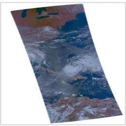
Hurricane Hanna Not Moving Much Near North of the Caicos Islands

Tropical Storm Hanna has virtually parked herself north of the Caicos Islands in the Atlantic Ocean, continuing to bring residents heavy rains and winds. A tropical storm warning remains in effect for the central and southeastern Bahamas and the Turks and Caicos islands.
This visible image of Hanna was created by data from the Atmospheric Infrared Sounder (AIRS), an instrument that flies aboard NASA's Aqua satellite. It was created on August 31 at 18:11 UTC (2:11 p.m. EDT).
At 8:00 a.m. EDT the center of Tropical Storm Hanna had maximum sustained winds near 50 mph. She was located near latitude 23.6 north and longitude 72.4 west or about 90 miles north-northeast of the southeastern Bahamas. She's been nearly stationary, drifting westward near 2 mph and will continue that way for the next day or two. On the forecast track the center of Hanna will move near or over the southeastern Bahamas during the next day or two. The estimated minimum central pressure is 996 millibars.
Rainfall expected through Thursday over the central and Southeastern Bahamas and the Turks and Caicos islands will be between 4 to 8 inches with maximum amounts near 12 inches. In addition, ocean swells are expected to increase the risk of dangerous rip currents along portions of the southeastern United States coast during the next couple of days.
Source: by Rob Gutro/Goddard Space Flight Center


